Extended Data
The MapShape object exposes a property called ExtendedData. It allows you to attach additional data to the shape. For example, if a shape represents a country on the map, you can use the ExtendedData property to attach information about the country such as Area, Capitol, Population etc. Later this data can be accessed through the ExtendedData property.
To learn more about the MapShape objects read here.
The ExtendedData represents a set of properties and their values. To access a value you have to use the property name as a key.
This topic will explain the following:
Extended Data and MapShapeReader
When generating shapes automatically from the various data formats via MapShapeReader, the Extended Data gets automatically extracted from the files and stored inside the ExtendedData property. This way you can directly use it where needed.
To learn more about the MapShapeReader object read here.
Manual Extended Data creation
In case you are manually generating the shapes inside a layer, you have to manually wrap and pass the data to the ExtendedData property. This one by using the ExtendedData and the ExtendedPropertySet classes. Here is an example:
<telerik:RadMap x:Name="radMap">
    <telerik:InformationLayer x:Name="informationLayer" />
</telerik:RadMap>
// Create extended property set.
// It can be shared between the number
// of the map shapes.
ExtendedPropertySet propertySet = new ExtendedPropertySet();
propertySet.RegisterProperty( "Name", "City Name", typeof( string ), String.Empty );
propertySet.RegisterProperty( "Population", "Population", typeof( int ), 0 );
MapEllipse sofiaEllipse = new MapEllipse()
{
    ShapeFill = new MapShapeFill()
    {
        Stroke = new SolidColorBrush( Colors.Red ),
        StrokeThickness = 2,
        Fill = new SolidColorBrush( Colors.Transparent )
    },
    Width = 20,
    Height = 20,
    Location = new Location( 42.6957539183824, 23.3327663758679 ),
};
// Create extended data for the ellipse
// using existing property set.
ExtendedData sofiaData = new ExtendedData( propertySet );
// Set the extended properties.
sofiaData.SetValue( "Name", "Sofia" );
sofiaData.SetValue( "Population", 1300000 );

// Assign extended data to the map shape.
sofiaEllipse.ExtendedData = sofiaData;
this.informationLayer.Items.Add( sofiaEllipse );
' Create extended property set.'
' It can be shared between the number'
' of the map shapes.'
Dim propertySet As New ExtendedPropertySet()
propertySet.RegisterProperty("Name", "City Name", GetType(String), String.Empty)
propertySet.RegisterProperty("Population", "Population", GetType(Integer), 0)
Dim sofiaEllipse As New MapEllipse() With {.ShapeFill = New MapShapeFill() With {.Stroke = New SolidColorBrush(Colors.Red), .StrokeThickness = 2, .Fill = New SolidColorBrush(Colors.Transparent)}, .Width = 20, .Height = 20, .Location = New Location(42.6957539183824, 23.3327663758679)}
' Create extended data for the ellipse'
' using existing property set.'
Dim sofiaData As New ExtendedData(propertySet)
' Set the extended properties.'
sofiaData.SetValue("Name", "Sofia")
sofiaData.SetValue("Population", 1300000)
' Assign extended data to the map shape.'
sofiaEllipse.ExtendedData = sofiaData
Me.informationLayer.Items.Add(sofiaEllipse)
Extended Data Converter
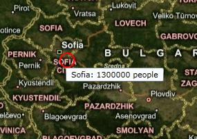
To access the data stored in the ExtendedData property simply bind directly to it and use the ExtendedDataConverter class, that comes out of the box with the RadMap. To get the desired value you have to also pass the name of the respective property from the set as the ConverterParameter. Here is an example, based on the one in the previous section:
You can pass a string to the ConvertParameter that combines the values of two or more properties from the Extended Data. To learn how to compose your format string read the following topic.
<telerik:RadMap x:Name="radMap">
    <telerik:InformationLayer x:Name="informationLayer" />
</telerik:RadMap>
ExtendedPropertySet propertySet = new ExtendedPropertySet();
propertySet.RegisterProperty( "Name", "City Name", typeof( string ), String.Empty );
propertySet.RegisterProperty( "Population", "Population", typeof( int ), 0 );
MapEllipse sofiaEllipse = new MapEllipse()
{
    ShapeFill = new MapShapeFill()
    {
        Stroke = new SolidColorBrush( Colors.Red ),
        StrokeThickness = 2,
        Fill = new SolidColorBrush( Colors.Transparent )
    },
    Width = 20,
    Height = 20,
    Location = new Location( 42.6957539183824, 23.3327663758679 ),
};
ExtendedData sofiaData = new ExtendedData( propertySet );
sofiaData.SetValue( "Name", "Sofia" );
sofiaData.SetValue( "Population", 1300000 );
sofiaEllipse.ExtendedData = sofiaData;
// Assign tooltip which uses the extended properties.
ToolTip tooltip = new ToolTip();
Binding tooltipBinding = new Binding()
{
    Converter = new ExtendedDataConverter(),
    ConverterParameter = "{Name}: {Population} people",
    Source = sofiaEllipse.ExtendedData
};
tooltip.SetBinding(ContentProperty, tooltipBinding );
ToolTipService.SetToolTip( sofiaEllipse, tooltip );
this.informationLayer.Items.Add( sofiaEllipse );
Dim propertySet As New ExtendedPropertySet()
propertySet.RegisterProperty("Name", "City Name", GetType(String), String.Empty)
propertySet.RegisterProperty("Population", "Population", GetType(Integer), 0)
Dim sofiaEllipse As New MapEllipse() With {.ShapeFill = New MapShapeFill() With {.Stroke = New SolidColorBrush(Colors.Red), .StrokeThickness = 2, .Fill = New SolidColorBrush(Colors.Transparent)}, .Width = 20, .Height = 20, .Location = New Location(42.6957539183824, 23.3327663758679)}
Dim sofiaData As New ExtendedData(propertySet)
sofiaData.SetValue("Name", "Sofia")
sofiaData.SetValue("Population", 1300000)
sofiaEllipse.ExtendedData = sofiaData
' Assign tooltip which uses the extended properties.'
Dim _tooltip As New ToolTip()
Dim tooltipBinding As New Binding() With {.Converter = New ExtendedDataConverter(), .ConverterParameter = "{Name}: {Population} people", .Source = sofiaEllipse.ExtendedData}
_tooltip.SetBinding(ContentProperty, tooltipBinding)
ToolTipService.SetToolTip(sofiaEllipse, _tooltip)
Me.informationLayer.Items.Add(sofiaEllipse)
Here is a snapshot of the result:
