Dynamic Layer
In contrast to InformationLayer which processes all items in a collection, the DynamicLayer requests items to process. It makes favour when thousands of items are available (pictures of POIs, for example). Your application can select what pictures are suitable for given location and zoom factor and return only these ones.
This allows you to implement items virtualization. It means that framework elements, pin points and map shapes are loaded when the region of the map they belong to is visible.
The DynamicLayer uses a request to get items to show when zoom or center property is changed and refreshes items collection every time when response contains new data. It also supports asynchronous requests, so that new items can be downloaded from the server only when they come into view.
This topic will explain the following:
Map Division
The DynamicLayer requires a division of the map space in regions. The division of map space is defined using the DynamicLayer.ZoomGridList collection. Each ZoomGrid should define a minimum zoom level for its division. Of course the maximum zoom level for a grid is the minimum zoom layer of the next grid in the list. Also each zoom level is divided in a grid of latitude/longitude divisions.
Here is an example of a DynamicLayer with a set of two ZoomGrids:
<telerik:RadMap x:Name="radMap"
                Width="600"
                Height="480">
    <telerik:DynamicLayer x:Name="dynamicLayer">
        <telerik:DynamicLayer.ZoomGridList>
            <telerik:ZoomGrid LatitudesCount="2"
                                LongitudesCount="2"
                                MinZoom="3" />
            <telerik:ZoomGrid LatitudesCount="4"
                                LongitudesCount="4"
                                MinZoom="6" />
        </telerik:DynamicLayer.ZoomGridList>
    </telerik:DynamicLayer>
</telerik:RadMap>
There are two grid lists - the one goes from zoom 3 to 6, and the other from zoom 6 to the maximum zoom. Also, the first grid has a 2 by 2 latitude/longitude division. This means that map is divided in 4 regions, and the layer only requests data for the current visible regions. The second slice is divided into 16 regions - higher zoom values require more divisions to perform well.
Dynamic Source
The data provided to the DynamicLayer should be wrapped in a class that implements the IMapDynamicSource interface. This interface contains the ItemsRequest() method, which is used by the DynamicLayer to make request for new data, whenever the zoom level or the region changes.
When there are no ZoomGrids that satisfy the current zoom level, no request would be made. Also when the changed value of the zoom level or the regionstays in the range of a ZoomGrid or one of it cells, no request is made neither. In the current case, for example, when the zoomlevel is 1 or 2, no requests would be made, because there is no grid which represent this range. When the value is bigger than 6, requests would be made only when the grid cell changes, because the gird is defined for the range from 6 to the maximal zoom level.
The following properties are used in the ItemsRequest() method from the DynamicLayer:
minZoom - represents the minimum zoom level of the currently active ZoomGrid.
upperLeft - represents the upper left corner of the currently visible region.
lowerRight - represents the lower right corner of the currently visible region.
CompleteItemsRequest - represents an Action, which is responsible to pass the desired item back to the DynamicLayer.
In this method you have to implement your logic for getting the desired items. The items can be represented by static and dynamic data as well. Here is an example of how to implement simple static functionality in the ItemsRequest() method.
If you want to deliver your data via a WebService you can follow our demo with full source code.
public class MapDynamicSource : IMapDynamicSource
{
    public void ItemsRequest(object sender, ItemsRequestEventArgs e)
    {
        List<object> items = new List<object>();
        double minZoom = e.MinZoom;
        Location upperLeft = e.UpperLeft;
        Location lowerRight = e.LowerRight;
           HotSpot centerSpot = new HotSpot();
        centerSpot.X = 0.5;
        centerSpot.Y = 0.5;
        Location bulgariaLocation = new Location(42.7669999748468, 25.2819999307394);
        LocationRect currentRegion = new LocationRect(upperLeft, lowerRight);

        if (currentRegion.Contains(bulgariaLocation))
        {
            if (minZoom == 3)
            {
                Ellipse ellipse = new Ellipse();
                ellipse.Width = 15;
                ellipse.Height = 15;
                ellipse.Fill = new SolidColorBrush(Colors.Red);
                ellipse.SetValue(MapLayer.LocationProperty, bulgariaLocation);
                MapLayer.SetHotSpot(ellipse, centerSpot);
                ToolTipService.SetToolTip(ellipse, "Bulgaria");
                items.Add(ellipse);
            }
            else if (minZoom == 6)
            {
                Ellipse sofiaEllipse = new Ellipse();
                sofiaEllipse.Width = 20;
                sofiaEllipse.Height = 20;
                sofiaEllipse.Stroke = new SolidColorBrush(Colors.Red);
                sofiaEllipse.Fill = new SolidColorBrush(Colors.Transparent);
                sofiaEllipse.StrokeThickness = 3;
                sofiaEllipse.SetValue(MapLayer.LocationProperty, new Location(42.6957539183824, 23.3327663758679));
                MapLayer.SetHotSpot(sofiaEllipse, centerSpot);
                ToolTipService.SetToolTip(sofiaEllipse, "Sofia");
                items.Add(sofiaEllipse);
            }
        }
        e.CompleteItemsRequest(items);
    }
}
Public Class MapDynamicSource
Implements IMapDynamicSource
  Public Sub ItemsRequest(ByVal sender As Object, ByVal e As ItemsRequestEventArgs)
        Dim items As New List(Of Object)()
        Dim minZoom As Double = e.MinZoom
        Dim upperLeft As Location = e.UpperLeft
        Dim lowerRight As Location = e.LowerRight
           Dim centerSpot As New HotSpot()
        centerSpot.X = 0.5
        centerSpot.Y = 0.5
        Dim bulgariaLocation As New Location(42.7669999748468, 25.2819999307394)
        Dim currentRegion As New LocationRect(upperLeft, lowerRight)

        If currentRegion.Contains(bulgariaLocation) Then
              If minZoom = 3 Then
                    Dim ellipse As New Ellipse()
                    ellipse.Width = 15
                    ellipse.Height = 15
                    ellipse.Fill = New SolidColorBrush(Colors.Red)
                    ellipse.SetValue(MapLayer.LocationProperty, bulgariaLocation)
                    MapLayer.SetHotSpot(ellipse, centerSpot)
                    ToolTipService.SetToolTip(ellipse, "Bulgaria")
                    items.Add(ellipse)
              ElseIf minZoom = 6 Then
                    Dim sofiaEllipse As New Ellipse()
                    sofiaEllipse.Width = 20
                    sofiaEllipse.Height = 20
                    sofiaEllipse.Stroke = New SolidColorBrush(Colors.Red)
                    sofiaEllipse.Fill = New SolidColorBrush(Colors.Transparent)
                    sofiaEllipse.StrokeThickness = 3
                    sofiaEllipse.SetValue(MapLayer.LocationProperty, New Location(42.6957539183824, 23.3327663758679))
                    MapLayer.SetHotSpot(sofiaEllipse, centerSpot)
                    ToolTipService.SetToolTip(sofiaEllipse, "Sofia")
                    items.Add(sofiaEllipse)
              End If
        End If
        e.CompleteItemsRequest(items)
  End Sub
End Class
You can set the dynamic source to a new instance of the MapDynamicSource and create a new definition for the AzureMapProvider:
public MainPage()
{
    InitializeComponent();
    this.radMap.Provider = new AzureMapProvider() { SubscriptionKey = "Your Subscription Key" };
    this.dynamicLayer.DynamicSource = new MapDynamicSource();
}
Public Sub New()
    InitializeComponent()
    this.radMap.Provider = new AzureMapProvider() { SubscriptionKey = "Your Subscription Key" };
    this.dynamicLayer.DynamicSource = new MapDynamicSource();
End Sub
The result:
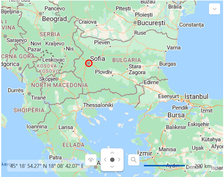
ZoomLevel = 3:
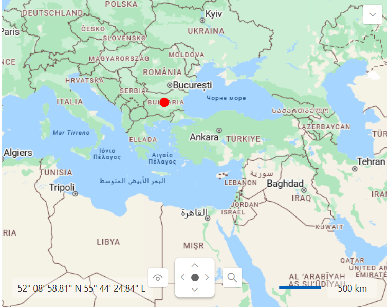
ZoomLevel = 6: