.NET MAUI Map Shapefile Layer
The MapShapefileLayer class provides a way to load an ESRI shapefile into the Map and visualize the shapes defined in it. You will need to create a MapShapefileLayer for each shapefile and add it to the Layers collection of RadMap.
Reading a Shapefile
MapShapefileLayer provides a Reader property used to read the data from the defined shapefile. The Reader is of type Telerik.Maui.Controls.Map.MapShapeReader and has two important properties you need to apply to properly load and visualize your shapes:
-
Source(of typeTelerik.Maui.Controls.Map.MapSource)—Gets or sets theMapSourcethat points to the.shpfile to read data from. -
DataSource(of typeTelerik.Maui.Controls.Map.MapSource)—Gets or sets theMapSourcethat points to the.dbffile, containing the data (or attributes) for each shape within the shape file.
The above used MapSource class provides a few useful static methods that will help load the shapefile:
FromResource(string resource, Assembly sourceAssembly)/FromResource(string resource, Type resolvingType): Two overrides you can choose from to createMapSourcefrom a provided embedded resource.FromStream(Stream stream)—Returns aMapSourcefrom a passed stream.-
FromFile(string file)—ReturnsMapSourcefrom a passed string the represents a specific file path.
In addition, MapShapeReader provides a read-only Shapes property that can be used to get a list of all the shapes that are read from the Source.
Getting Best View
MapShapefileLayer provides a way to visualize the shapes in such a way that the best view of the layer is achieved. The approach is implemented through the GetBestView method:
-
GetBestView()(structof typeTelerik.Maui.Controls.ShapefileReader.LocationRect)—Gets a location rectangle, which represents the best view for the layer.
First, the LocationRect class is a special type from the Telerik.Maui.Controls.ShapefileReader namespace which describes a rectangular region through the locations of the northwest to the southeast points.
For more details on how points are positioned in the geographic coordinate system, check the Layers Overview topic.
So, through GetBestView method the map will calculate that region that encompasses all the shapes as well as apply proper zoom level, so that the best view is achieved. After that, you can pass the result directly to the SetView method of the Map instance like this:
var bestView = this.mapShapeLayer.GetBestView();
this.map.SetView(bestView);
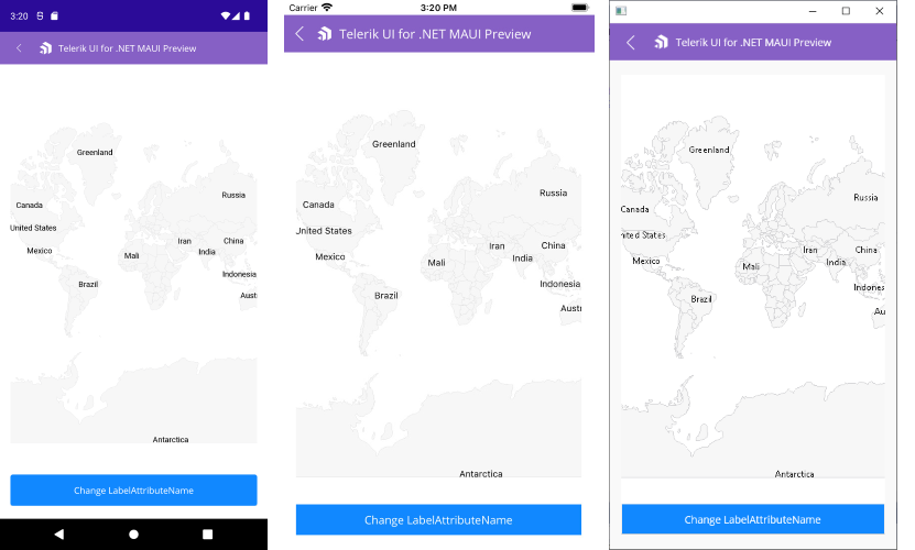
Labels
You can add a label for each shape in a MapShapefileLayer by setting the LabelAttributeName property to an attribute from the .dbf file specified in the DataSource property of the layer.
Check below a quick example:
<telerik:RadMap x:Name="map">
    <telerik:RadMap.Layers>
        <telerik:MapShapefileLayer x:Name="mapShapeLayer" LabelAttributeName="CNTRY_NAME">
            <telerik:MapShapefileLayer.Reader>
                <telerik:MapShapeReader x:Name="reader"/>
            </telerik:MapShapefileLayer.Reader>
        </telerik:MapShapefileLayer>
    </telerik:RadMap.Layers>
</telerik:RadMap>
where the Source and the DataSource of the MapShapeReader have to be defined to a .shp and .dbf files, respectively:
var assembly = this.GetType().Assembly;
var source = MapSource.FromResource("SDKBrowserMaui.Examples.MapControl.world.shp", assembly);
var dataSource = MapSource.FromResource("SDKBrowserMaui.Examples.MapControl.world.dbf", assembly);
this.reader.Source = source;
this.reader.DataSource = dataSource;
Selection
RadMap supports single and multiple selection of shapes to help you draw attention on specific areas. You will need to set SelectionMode property of the ShapefileLayer to enable the selection.
SelectionMode can receive the following values:
- None;
- Single;
- Multiple.
Read the Selection topic for more details about this feature.
Styling
RadMap provides the option to apply various Fill and Stroke colors to the shapes to make the map consecutive with the design of the app. For more details check Styling article.