Drawing Markers and Regions
Please note that Bing Maps will be deprecated effective June 30, 2025. As an alternative, users can refer to the SDK example available in our GitHub repository, which demonstrates how to create a custom provider using the Azure Maps API. A valid Azure Maps subscription key is required to use this functionality.
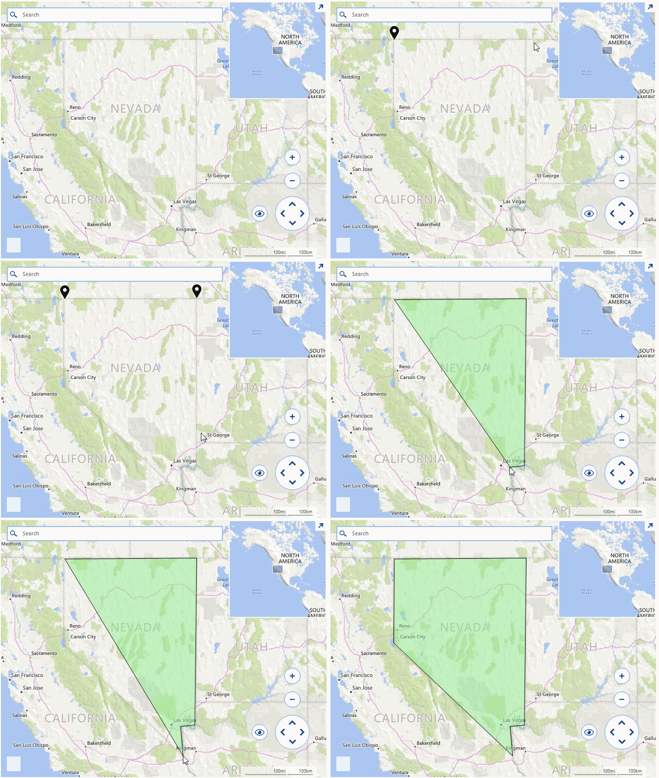
A common requirement for applications utilizing a map control is to allow the end users add pins on the map and draw regions on it. RadMap exposes the necessary API and it can be easily extended with such functionalities. The example in this how-to article will handle a scenario in which pins are being added on the map after double clicking on it. As soon as the count of the markers increases to three so that they form a figure a region will be created.
Figure 1: RadMap Pins and Regions

RadMap is handling the mouse, keyboard, and gestures by a special input behavior class. This class can be inherited and further extended to handle custom scenarios. In our example we will override its OnDoubleClick method and execute our special logic for adding the pins and the regions. The custom provider class can be assigned to the map by simply setting its InputBehavior property.
This example uses the BingRestMapProvider and the control is initially setup according to this article.
Setup Provider
BingRestMapProvider bingProvider = new BingRestMapProvider();
bingProvider.ImagerySet = ImagerySet.Road;
bingProvider.UseSession = true;
bingProvider.BingKey = this.bingKey;
bingProvider.InitializationComplete += delegate (object sender, EventArgs e)
{
    this.radMap1.BringIntoView(new PointG(40d, -99d), 4);
};
LocalFileCacheProvider cache = new LocalFileCacheProvider(Path.Combine(Path.GetTempPath(), "cache"));
bingProvider.CacheProvider = cache;
this.radMap1.MapElement.Providers.Add(bingProvider);
MapLayer pinsLayer = new MapLayer("Pins");
this.radMap1.Layers.Add(pinsLayer);
this.radMap1.InputBehavior = new CustomMapInputBehavior();
Dim bingProvider As New BingRestMapProvider()
bingProvider.ImagerySet = ImagerySet.Road
bingProvider.UseSession = True
bingProvider.BingKey = Me.bingKey
AddHandler bingProvider.InitializationComplete, Sub(sender As Object, e As EventArgs) Me.radMap1.BringIntoView(New PointG(40.0, -99.0), 4)
Dim cache As New LocalFileCacheProvider(Path.Combine(Path.GetTempPath(), "cache"))
bingProvider.CacheProvider = cache
Me.radMap1.MapElement.Providers.Add(bingProvider)
Dim pinsLayer As New MapLayer("Pins")
Me.radMap1.Layers.Add(pinsLayer)
Me.radMap1.InputBehavior = New CustomMapInputBehavior()
In our custom implementation, we will add pins as long as their count is less than three, from then on each double click on the map while holding the Ctrl key will result in drawing a region enclosing all of the added points.
CustomMapInputBehavior Implementation
public class CustomMapInputBehavior : MapInputBehavior
{
    public override void OnDoubleClick(EventArgs e)
    {
        MouseEventArgs args = e as MouseEventArgs;
        if (args.Button == MouseButtons.Left && Control.ModifierKeys == Keys.Control)
        {
            PointL point = new PointL(args.X - this.MapElement.PanOffset.Width, args.Y - this.MapElement.PanOffset.Height);
            PointG location = MapTileSystemHelper.PixelXYToLatLong(point.X, point.Y, this.MapElement.ZoomLevel);
            while (location.Longitude > 180)
            {
                location.Longitude -= 360;
            }
            if (this.MapElement.Layers[0].Overlays.Count > 1 || (this.MapElement.Layers[0].Overlays.Count > 0 && this.MapElement.Layers[0].Overlays[0] is MapPolygon))
            {
                List<PointG> points = new List<PointG>();
                foreach (MapVisualElement element in this.MapElement.Layers[0].Overlays)
                {
                    MapPin pin = element as MapPin;
                    if (pin != null)
                    {
                        points.Add(element.Location);
                    }
                    MapPolygon pol = element as MapPolygon;
                    if (pol != null)
                    {
                        points.AddRange(pol.OuterBoundary);
                    }
                }
                points.Add(location);
                this.MapElement.Layers[0].Clear();
                MapPolygon polygon = new MapPolygon(points);
                polygon.BackColor = Color.FromArgb(125, Color.LightGreen);
                this.MapElement.Layers[0].Add(polygon);
            }
            else
            {
                MapPin pin = new MapPin(location);
                this.MapElement.Layers[0].Add(pin);
            }
        }
        else
        {
            base.OnDoubleClick(e);
        }
    }
}
Public Class CustomMapInputBehavior
    Inherits MapInputBehavior
    Public Overrides Sub OnDoubleClick(e As EventArgs)
        Dim args As MouseEventArgs = TryCast(e, MouseEventArgs)
        If args.Button = MouseButtons.Left AndAlso Control.ModifierKeys = Keys.Control Then
            Dim point As New PointL(args.X - Me.MapElement.PanOffset.Width, args.Y - Me.MapElement.PanOffset.Height)
            Dim location As PointG = MapTileSystemHelper.PixelXYToLatLong(point.X, point.Y, Me.MapElement.ZoomLevel)
            While location.Longitude > 180
                location.Longitude -= 360
            End While
            If Me.MapElement.Layers(0).Overlays.Count > 1 OrElse (Me.MapElement.Layers(0).Overlays.Count > 0 AndAlso TypeOf Me.MapElement.Layers(0).Overlays(0) Is MapPolygon) Then
                Dim points As New List(Of PointG)()
                For Each element As MapVisualElement In Me.MapElement.Layers(0).Overlays
                    Dim pin As MapPin = TryCast(element, MapPin)
                    If pin IsNot Nothing Then
                        points.Add(element.Location)
                    End If
                    Dim pol As MapPolygon = TryCast(element, MapPolygon)
                    If pol IsNot Nothing Then
                        points.AddRange(pol.OuterBoundary)
                    End If
                Next
                points.Add(location)
                Me.MapElement.Layers(0).Clear()
                Dim polygon As New MapPolygon(points)
                polygon.BackColor = Color.FromArgb(125, Color.LightGreen)
                Me.MapElement.Layers(0).Add(polygon)
            Else
                Dim pin As New MapPin(location)
                Me.MapElement.Layers(0).Add(pin)
            End If
        Else
            MyBase.OnDoubleClick(e)
        End If
    End Sub
End Class