Tiles
Please note that Bing Maps will be deprecated effective June 30, 2025. As an alternative, users can refer to the SDK example available in our GitHub repository, which demonstrates how to create a custom provider using the Azure Maps API. A valid Azure Maps subscription key is required to use this functionality.
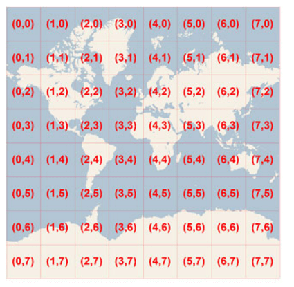
Bing Maps provide a world map that users can easily pan and zoom. In order to achieve smooth users interaction, the map is pre-rendered at many detailed levels where each level is cut into tiles of 256 x 256 pixels each. Each tile is given XY coordinates ranging from (0, 0) in the upper left to (2level–1, 2level–1) in the lower right. For example, at level 3 the tile coordinates range from (0, 0) to (7, 7) as follows:
Figure 1: Tile XY coordinates at level 3
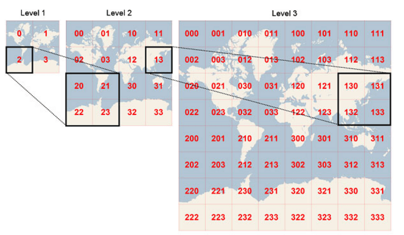
In order to optimize the tiles indexing, the two-dimensional tile XY coordinates are combined into one-dimensional strings called quadtree keys, or “quadkeys” for short. Each quadkey uniquely identifies a tile and it can be used as a key in common database B-tree indexes. To convert tile coordinates into a quadkey, the bits of the Y and X coordinates are interleaved, and the result is interpreted as a base-4 number (with leading zeros maintained) and converted into a string. For instance, given tile XY coordinates of (3, 5) at level 3, the quadkey is determined as follows:
tileX = 3 = 0112
tileY = 5 = 1012
quadkey = 1001112 = 2134 = “213”
Figure 2: Tile Quadkeys
Finally, tiles that are close to each other have quadkeys that are relatively close together. This is important for optimizing performance, because neighboring tiles are usually requested in groups.