MapUserLayer
MapUserLayer Properties
The MapShapeLayer class inherits from the MapLayer class - See the inherited properties.
The MapUserLayer exposes the following properties:
- ItemsSource (IEnumerable): Gets or sets the collection of data items to be visualized by the layer. > This property has to be bound to a property fromthe view model. The items in the ItemsSource could be of any type that has a property of type Location that specifies the geographic position where the item will be rendered. If the items are of MapDataItem type, the MapUserLayer can use them without specifying the LocationPropertyName and the LocationOriginPropertyName.
- ItemTemplate (DataTemplate): Gets or sets the DataTemplate that defines the visual representation of each data item present within the ItemsSource.
- ItemTemplateSelector (DataTemplateSelector): Gets or sets the DataTemplateSelector that may be used to provide context-based appearance for each data item within the ItemsSource.
- LocationPropertyName (string):Gets or sets the name of the property that contains the GeoSpatial.Location value for each item in the ItemsSource. The expected return value of the property is of type Telerik.Geospatial.Location.
- LocationOriginPropertyName (string): Gets or sets the name of the property that defines the origin of the item relative to the Geo Location of the item. A value of (0.5, 0.5) will center the visual representation of each item over its geographical location. The expected return value of the property is of type Windows.Foundation.Point.
- MinZoomPropertyName (string):Gets or sets the name of the property that contains the minimum zoom level needed for the item to be displayed. The expected return value of the property is of type double.
- MaxZoomPropertyName (string): Gets or sets the name of the property that contains the maximum zoom level needed for the item to be displayed. The expected return value of the property is of type double.
MapDataItem Class
Here are listed the properties exposed by the MapDataItem class.
- MinZoom (double): Gets or sets the minimum of the zoom range in which the item is visible.
- MaxZoom (double): Gets or sets the maximum of the zoom range in which the item is visible.
- Location (Location): Gets or sets the geographic location where the item needs to be displayed.
- LocationOrigin (Point): Gets or sets a value that defines how the visual representation of the data item is aligned with the physical coordinates of the Location property. The default value of (0.5, 0.5) will center the visual representation over the geographic location.
Example
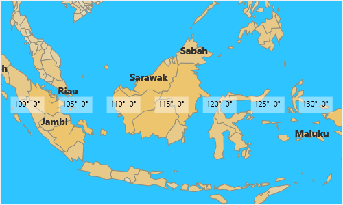
Here is an example of how to add a MapUserLayer to the RadMap. The layer will contain several items and it will visualize their coordinates (longitude, latitude) in a TextBlock. Usually the MapUserLayer will be used to show additional information to a MapShapeLayer, that is why we have added additional MapShapeLayer to the map.
-
First, create a view model class that contains a collection of MapDataItem objects. The view model will be used as a DataSource for the RadMap control.
public class ViewModel { public ViewModel() { this.UserShapes = GetData(); } public ICollection<IMapDataItem> GetData() { var data = new List<IMapDataItem>(); for (var i = -180; i <= 180; i += 5) { data.Add(new MapDataItem { Location = new Location(0, i) }); } return data; } public ICollection<IMapDataItem> UserShapes { get; set; } } -
Then add a MapUserLayer to the Layers collection of the map and bind its ItemsSource property to a property of the view model. You also have to define an ItemTemplate that will specify how the items will be visualized.
<telerikMap:RadMap Background="#2EC4FF">
    <telerikMap:RadMap.DataContext>
        <local:ViewModel/>
    </telerikMap:RadMap.DataContext>
    <telerikMap:RadMap.Layers>

        <telerikMap:MapUserLayer ItemsSource="{Binding UserShapes}">
            <telerikMap:MapUserLayer.ItemTemplate>
                <DataTemplate>
                    <Border BorderThickness="1" Background="#70FFFFFF">
                        <TextBlock Margin="5">
                            <Run Text="{Binding Location.Longitude}"/><Run Text="° "/>
                            <Run Text="{Binding Location.Latitude}"/><Run Text="°"/>
                        </TextBlock>
                    </Border>
                </DataTemplate>
            </telerikMap:MapUserLayer.ItemTemplate>
        </telerikMap:MapUserLayer>

        <telerikMap:MapShapeLayer ShapeLabelAttributeName="ADMIN_NAME">
            <telerikMap:MapShapeLayer.Source>
                <telerikMap:ShapefileDataSource SourceUriString="ms-appx:///Data/global.shp" DataSourceUriString="ms-appx:///Data/global.dbf"/>
            </telerikMap:MapShapeLayer.Source>
            <telerikMap:MapShapeLayer.ShapeColorizer>
                <telerikMap:DesaturationColorizer BaseColor="#FFBD2E" AttributeName="SQKM_ADMIN" From="1" To="0" RangeCount="10">
                    <telerikMap:DesaturationColorizer.RangeDistribution>
                        <telerikMap:LogarithmicRangeDistribution/>
                    </telerikMap:DesaturationColorizer.RangeDistribution>
                </telerikMap:DesaturationColorizer>
            </telerikMap:MapShapeLayer.ShapeColorizer>
        </telerikMap:MapShapeLayer>
    </telerikMap:RadMap.Layers>
</telerikMap:RadMap>
Here is the result: