Server-side
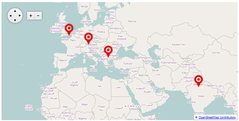
The markers and layers of the ASP.NET AJAX Map control can be bound both client-side client-side and server-side, as the way to achieve the later is described in this article. In Example 1 you will see how to bind RadMap with a server-side collection, as the result from this sample is shown in Figure 1. You can also use the RadMap's OnItemCreared and OnItemDataBound server-side events to additionally manipulate the data.
RadMap can use the standard data sources for binding an ASP.NET control:
Declarative ASP.NET data sources (SqlDatasource, ObjectDataSource, LinqDataSource, etc.)
Server-side collections that implement the IEnumerable interface.
Figure 1: Binding layers and markers in RadMap to a collection of custom objects.
Binding Markers
Similar to setting a data source for an ASP.NET control, you should either use the DataSourceID property when data binding markers declaratively or DataSource when the data source of the control is set on the server (such is the case in Example 1).
The data source should have columns for each of the map fields that you want to specify. For example, if you want to pull the title of the markers from the data source, this will require a separate column that contains the titles of each marker.
The columns of the data source are attached to their corresponding data fields in the markers via the properties with the structure Data[field name]Name in RadMap > DataBindings > MarkerBinding. For example: DataShapeField, DataTitleField, etc. You can find the full set of the MapMarker object's properties in the Server-Side API of RadMap.
Binding the Marker's Shape value can enable you to create an optional, custom look of the bound markers. You can examine the Customizing Markers in RadMap article.
Binding Layers
Following the same logic, when binding layers you should use either the LayersDataSourceID property when data binding layers declaratively or LayersDataSource when the data source of the control is set on the server (you can refer Example 1 for a sample configuration).
The columns of the data source here are also attached to their corresponding data fields in the layers via the properties with the structure Data[field name]Name in RadMap > DataBindings > LayerBinding. For example: DataTypeField, DataUrlTemplateField, etc. You can find the full set of the MapLayer object's properties in the Server-Side API of RadMap.
Examples
In the example below you will see a way to databind the layers and the markers of a RadMap control to a server-side object. The result of this code is shown in Figure 1.
Example 1: Data binding layers and markers in a map to a collection of custom objects.
<telerik:RadMap RenderMode="Lightweight" runat="server" ID="RadMap1" Zoom="3" Width="800" Height="400">
    <CenterSettings Latitude="40" Longitude="30" />
    <DataBindings>
        <LayerBinding
            DataTypeField="type"
            DataUrlTemplateField="urlTemplate"
            DataAttributionField="attribution"
            DataSubdomainsField="subdomains"
            DataMaxZoomField="maxZoom"
            DataMinZoomField="minZoom"
            DataOpacityField="opacity" />
        <MarkerBinding
            DataShapeField="shape"
            DataTitleField="title"
            DataLocationLatitudeField="locationLatitude"
            DataLocationLongitudeField="locationLongitude"
            DataTooltipTemplateField="tooltipTemplate" />
    </DataBindings>
</telerik:RadMap>
protected void Page_Load(object sender, EventArgs e)
{
if (!IsPostBack)
{
RadMap1.LayersDataSource = GetLayers();
RadMap1.DataSource = GetMarkers();
RadMap1.DataBind();
}
}
private IEnumerable GetLayers()
{
return new[] {
new {type=Telerik.Web.UI.Map.LayerType.Tile,
urlTemplate="https://#= subdomain #.tile.openstreetmap.org/#= zoom #/#= x #/#= y #.png",
attribution="© <a href='https://osm.org/copyright' title='OpenStreetMap contributors' target='_blank'>OpenStreetMap contributors</a>.",
subdomains="a,b,c",
maxZoom="3",
minZoom="1",
opacity="1"
}
};
}
private IEnumerable GetMarkers()
{
return new[] {
new {shape="pinTarget", title="Sofia", locationLatitude=42.650613, locationLongitude=23.379025, tooltipTemplate="#= location.lat # #= marker.options.title #"},
new {shape="pinTarget", title="Munich", locationLatitude=48.117227, locationLongitude=11.601990, tooltipTemplate="#= location.lat # #= marker.options.title #"},
new {shape="pinTarget", title="London", locationLatitude=51.515986, locationLongitude=-0.085798, tooltipTemplate="#= location.lat # #= marker.options.title #"},
new {shape="pinTarget", title="Gurgaon", locationLatitude=28.410139, locationLongitude=77.042439, tooltipTemplate="#= location.lat # #= marker.options.title #"}
};
}
Protected Sub Page_Load(sender As Object, e As EventArgs) Handles Me.Load
If Not IsPostBack Then
RadMap1.LayersDataSource = GetLayers()
RadMap1.DataSource = GetMarkers()
RadMap1.DataBind()
End If
End Sub
Private Function GetLayers() As IEnumerable
Return New Object() {New With { _
.type = Telerik.Web.UI.Map.LayerType.Tile, _
.urlTemplate = "https://#= subdomain #.tile.openstreetmap.org/#= zoom #/#= x #/#= y #.png", _
.attribution = "© <a href='https://osm.org/copyright' title='OpenStreetMap contributors' target='_blank'>OpenStreetMap contributors</a>.", _
.subdomains = "a,b,c", _
.maxZoom = "3", _
.minZoom = "1", _
.opacity = "1" _
}}
End Function
Private Function GetMarkers() As IEnumerable
Return New Object() {
New With {.shape = "pinTarget", .title = "Sofia", .locationLatitude = 42.650613, .locationLongitude = 23.379025, .tooltipTemplate = "#= location.lat # #= marker.options.title #"},
New With {.shape = "pinTarget", .title = "Munich", .locationLatitude = 48.117227, .locationLongitude = 11.60199, .tooltipTemplate = "#= location.lat # #= marker.options.title #"},
New With {.shape = "pinTarget", .title = "London", .locationLatitude = 51.515986, .locationLongitude = -0.085798, .tooltipTemplate = "#= location.lat # #= marker.options.title #"},
New With {.shape = "pinTarget", .title = "Gurgaon", .locationLatitude = 28.410139, .locationLongitude = 77.042439, .tooltipTemplate = "#= location.lat # #= marker.options.title #"}
}
End Function